Friday, April 19, 2024
Friday, April 19, 2024 @ 8:00 AM
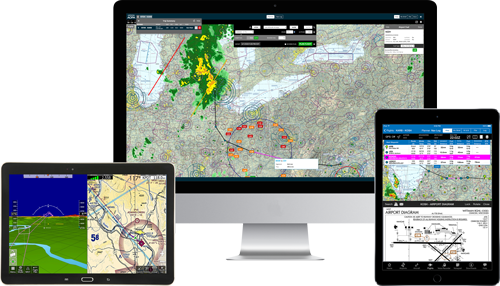
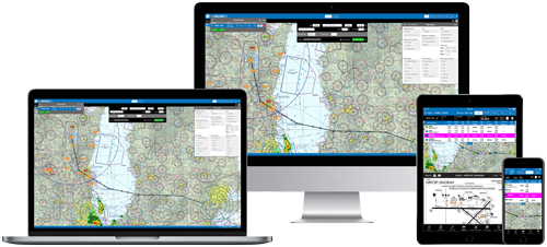
Not planning with an iFlightPlanner Premium membership is likely costing you - using these four simple planning tools will help save you fuel, time, and money every time you fly!
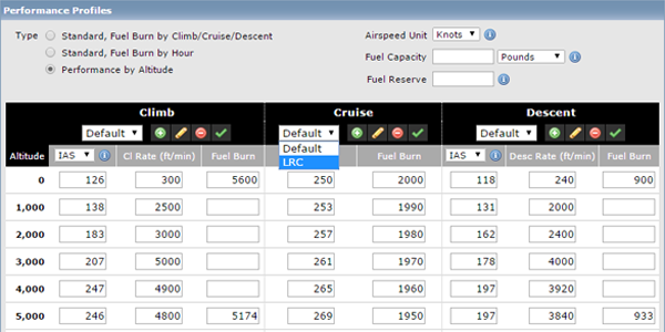
Detailed Aircraft Performance Profiles
iFlightPlanner offers the most detailed aircraft performance profiles of any flight planning solution. Not only can you input performance data by altitude, but as an iFlightPlanner Premium, you're able to create and plan using multiple performance profiles that will maximize your aircraft's range or cruise speed. The flight planner is so robust that it interpolates aircraft performance based on all available data, and gets more precise as you add details to the profile for each altitude.
Do you have performance profiles that you've perfected for your aircraft? Let us know, the iFlightPlanner Crew will be happy to help add it to your account!
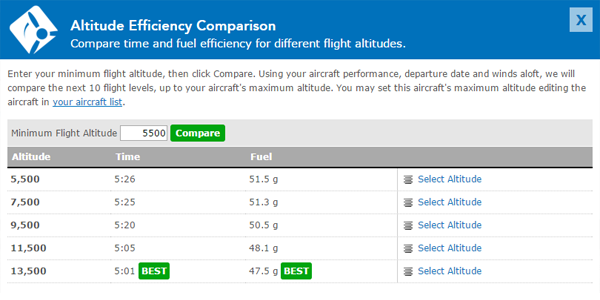
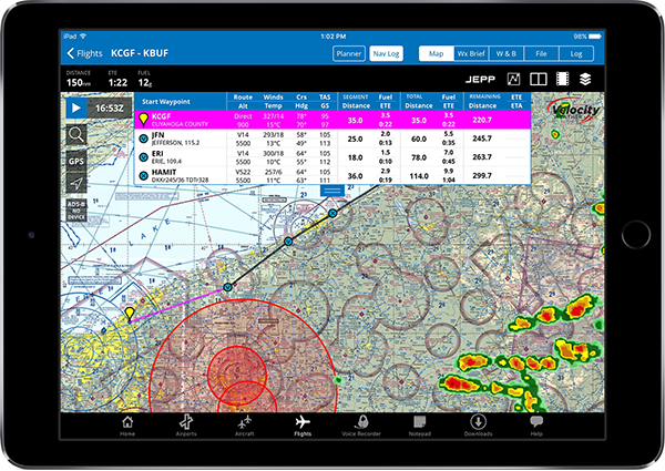
Altitude Efficiency Comparison Tool
Leveraging your detailed aircraft performance profiles, iFlightPlanner can compare every altitude (up to your aircraft's maximum) to identify the quickest, and most fuel-efficient altitudes for your flight. Simply click the Compare Altitudes button in the online Flight Planning Interface or in iFlightPlanner for iPad to discover the fuel savings waiting for you enroute!
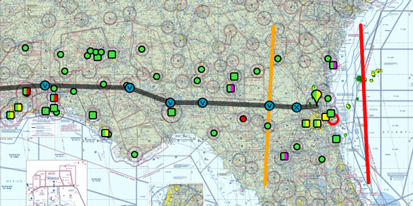
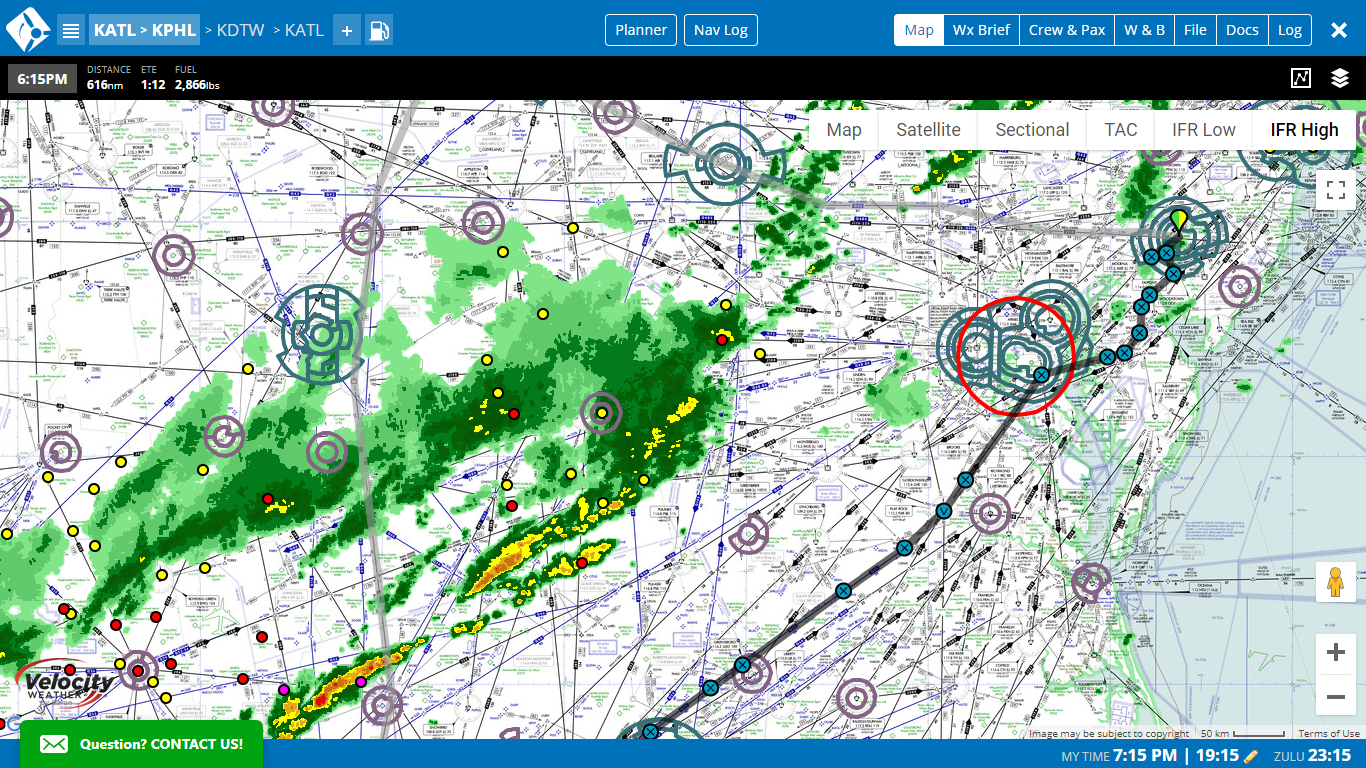
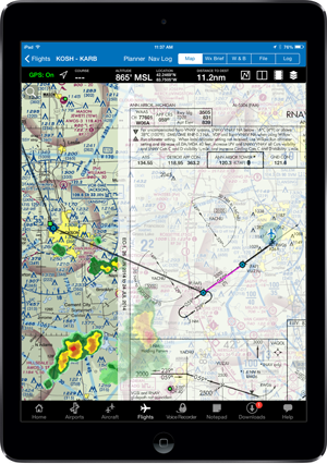
Aircraft Fuel Range Mapping
Instantly see if you can reach your destination non-stop, or know when you'll begin burning your predetermined reserve fuel with our fuel range identifiers. The orange marker shows where you'll tap into your reserve, while the red marker indicates the maximum range of your aircraft given your route, aircraft performance, and forecasted winds. Each fuel setting is available when editing an aircraft from your My Aircraft list, allowing the markers to appear on the map automatically for iFlightPlanner Premium.
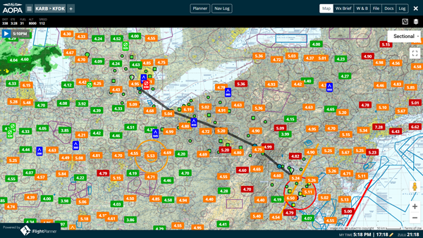
Graphical Fuel Price Map Layers
Turn on the fuel price layers in any of our interactive maps, including iFlightPlanner for iPad, to get a look at the most recently reported fuel prices across the country. Each fuel price links to our comprehensive Airport/Facility Directory for each airport, complete with FBO details, runway information, and printable airport diagrams and instrument approach procedures.

Using another EFB but want to switch to iFlightPlanner and take advantage of these great features? Our Competitive Upgrade Program allows you to trade-in your existing subscription and have the time remaining on it added to your new iFlightPlanner Premium.
If you have any questions, please send us a message. We are always happy to help and want you to get the most out of your iFlightPlanner experience!
Wednesday, March 24, 2021
Wednesday, March 24, 2021 @ 2:00 PM
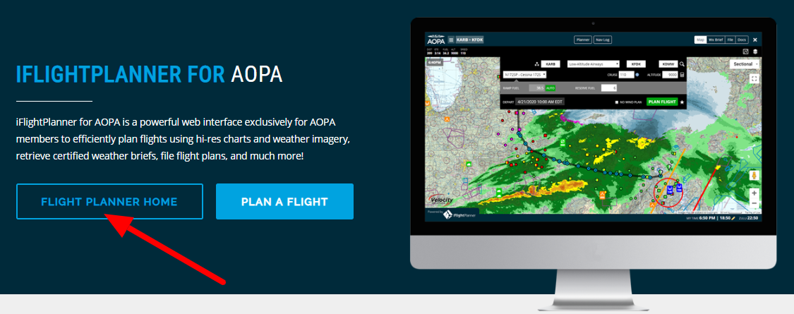
iFlightPlanner and AOPA have announced an expansion of their partnership, naming iFlightPlanner as the "Official Fuel Price Provider" of the member organization. iFlightPlanner will provide daily fuel price updates from over 3,400 FBOs and fuel service providers through the AOPA Airports and Destinations Directory, the AOPA mobile apps for iOS and Android, and iFlightPlanner for AOPA - the powerful flight planning interface included with your AOPA membership.
iFlightPlanner's web-based platforms, including iFlightPlanner for AOPA, along with iFlightPlanner for iPad and iFlightPlanner for iPhone allow you to plan flights using hi-res charts and weather imagery, retrieve weather briefs, file flight plans, and much more! All platforms up-to-date include access to posted retail self and full-serve prices for 100LL, MOGAS, UL94, JET-A, and JET-A with FSII.
“We know prices play a role in where pilots decide to stop for fuel,” said Eric Rush, AOPA director of product development. “With iFlightPlanner, we can provide the most up-to-date information possible for a wider variety of fuels across all our platforms.”
Andy Matthews, Director of Business Development at iFlightPlanner added, "We strive to maintain the most current retail fuel price database in the industry. If you are a fuel service provider looking for direct access to your pricing, or a pilot reporting a new price, please contact us!"
» READ MORE: IFLIGHTPLANNER TO UPDATE FUEL PRICES DAILY IN AOPA PRODUCTS
Tuesday, December 1, 2020
Tuesday, December 1, 2020 @ 10:00 AM
iFlightPlanner’s “Bring Your Own EFB” program, launched this summer in response to AOPA members’ desire to push flights planned with iFlightPlanner to their preferred Electronic Flight Bag (EFB), has been enhanced through a powerful integration with iFly GPS.
iFlightPlanner Core and iFlightPlanner Premium Members who plan a flight with iFlightPlanner or iFlightPlanner for AOPA will now have the ability to wirelessly sync flights to iFly GPS’ apps for Android, Windows, and Apple mobile devices.
With the newly released v11.1 of iFly GPS, users can now navigate to the iFlightPlanner settings via the Flight Plan > More Options menus and follow the on-screen instructions to connect the two platforms using their iFlightPlanner credentials, which will allow for any new or changed flight plans to wirelessly sync between iFlightPlanner and iFly GPS, automatically.
For AOPA members who are users of iFly GPS and wish to add the wireless sync capabilities with iFlightPlanner, special discounted pricing for iFlightPlanner Core and iFlightPlanner Premium memberships is detailed at iflightplanner.aopa.org/aopa.

The new features, as well as a live Q&A with participants, will be featured in a livestream hosted by Eric Rush, AOPA’s Director of Product Development, on the AOPA Live YouTube channel at 8pm EST (5pm PST) tomorrow, December 2. Members may tune in by heading to youtube.com/c/aopalive/live.
» OFFICIAL PRESS RELEASE
Tuesday, July 7, 2020
Tuesday, July 7, 2020 @ 8:00 AM
To access iFlightPlanner for AOPA as part of your member benefit you do not need separate credentials for iFlightPlanner – simply head to https://www.aopa.org/iflightplanner.
1. When logged in to your AOPA account you'll see two options to access iFlightPlanner, like this:
2. Click the "Flight Planner Home" button, and when you access iFlightPlanner for AOPA for the first time you'll be guided through the New Member Setup process which can be previewed here:
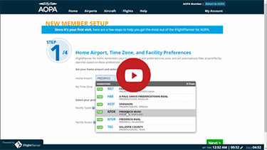
Click the red PLAY button to watch the YouTube clip.
Questions about iFlightPlanner for AOPA?
» iFlightPlanner for AOPA User Guide
» iFlightPlanner for AOPA Support Request Form
If you are an existing iFlightPlanner member and would like your account consolidated with your iFlightPlanner for AOPA membership, please contact iFlightPlanner directly and a member of our crew will be happy to help!
Wednesday, April 22, 2020
Wednesday, April 22, 2020 @ 11:05 AM
When AOPA announced that the legacy software powering AOPA’s popular online flight planning tool would be discontinued by the end of April, the associations information technology leaders were already hard at work finding a replacement to meet AOPA members’ needs. That replacement flight planning tool became available on April 22.
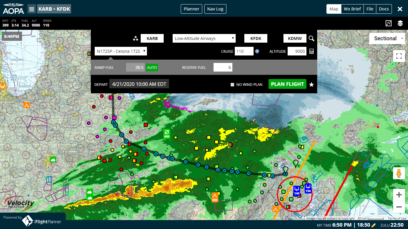
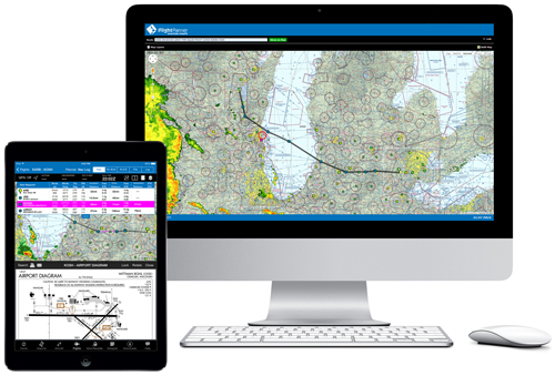
iFlightPlanner: Intuitively plan routes over hi-res charts with graphical weather overlays.
As the legacy flight planner sunsets, AOPA leaders expressed deep gratitude to Boeing and its Jeppesen team for their long support of the historic AOPA product and their help in transitioning to a new membership offering.
While working on the transition to a new planner, we listened carefully to feedback about what members value most for flight planning tools in an online or desktop environment. The result is a new partnership with iFlightPlanner that combines a new technology platform with a core set of features that AOPA members have long been asking for. iFlightPlanner, an Ann Arbor, Michigan-based firm, is providing a unique version of its flight planning platform exclusively to AOPA members free of charge.
“AOPA is pleased to offer members access to a very capable web-based flight planner, customized with many features especially for AOPA pilots,” said Jiri Marousek, AOPA senior vice president of marketing. “Beginning April 22, members can use a customized version of iFlightPlanner accessible through any web browser on desktop, tablet, and mobile devices. We have been working with iFlightPlanner to offer several new features not previously available, including options free to AOPA pilots that are otherwise only included in paid versions of their products.”
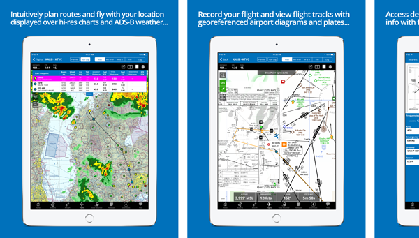
The planner combines the newer technology and graphical capabilities of iFlightPlanner with their version of a select set of features that were most commonly used by AOPA members in the legacy system. One of the most important additions will be a powerful web interface with FAA-produced aeronautical charts and other visual displays related to weather, airspace, and airport services designed to provide pilots the most current information to effectively plan their flights. READ MORE »
Wednesday, April 22, 2020 @ 11:00 AM
In conjunction with AOPA's announcement of the customized version of iFlightPlanner now available to its members free of charge, iFlightPlanner has revised its available membership tiers.
Most notably is the introduction of iFlightPlanner Core, a set of essential flight planning tools with integrated web and iOS capabilities for $49.99/year. Pilots flying with iFlightPlanner Core have access to interactive route planning with graphical weather overlays, the ability to retrieve certified weather briefs from Leidos Flight Service/1800WXBRIEF, and flight plan filing from any internet-connected device. With wireless 2-way sync between iFlightPlanner for iPad and iFlightPlanner for iPhone, iFlightPlanner Core members can take their planning on the go with GPS moving map functionality for a true electronic flight bag (EFB) experience.
Enhanced functionality previously available through iFlightPlanner Premium and iFlightPlanner Premium Plus have been combined into a single iFlightPlanner Premium membership for $99.99/year. Lead by multi-leg flight and fuel planning capabilities, an integrated weight & balance caluculator, pilot logbook, and georeferenced airport diagrams and instrument procedures in iFlightPlanner for iPad and iFlightPlanner for iPhone, iFlightPlanner's top-level membership is now more affordable than ever!
What's happening to my iFlightPlanner membership?
iFlightPlanner Free members now have access to iFlightPlanner Core, free for 60 days!
iFlightPlanner Premium members now have access to features previously reserved for iFlightPlanner Premium Plus members!
iFlightPlanner Premium Plus members now have access to all the features they've come to know and trust for less than $100/year!
iFlightPlanner's freely available charts interface with basic route planning will continue to be available at iFlightPlanner.com/AviationCharts. Pilots who wish to upgrade their flight planning experience with iFlightPlanner Core or iFlightPlanner Premium may do so HERE, with AOPA members saving 20% on all annual memberships.
Current iFlightPlanner members with questions about their individual membership are encouraged to contact the iFlightPlanner Crew directly by clicking HERE.
Monday, November 25, 2019
Monday, November 25, 2019 @ 8:00 AM
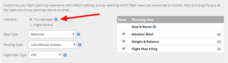
We're excited to share that we will be sunsetting our original, single-leg flight planning process (the Flight Wizard) and transition all members to the more versatile multi-leg Trip Manager on December 15, 2019 at 08:00Z!

The Trip Manager interface builds on the step-by-step Flight Wizard, ensuring every aspect of your flight, from interactive route and weather planning, the retrieval of certified weather briefs, weight & balance calculations, flight plan filing, and record keeping via your digital log book, is completed in sequential, efficient steps.
 Click HERE for a sharable screenshot!
All personal settings, aircraft, and flights created via the Trip Manager will continue to automatically sync wirelessly with iFlightPlanner for iPad, currently available in the App Store. Current iFlightPlanner members should point their browser to www.iFlightPlanner.com/My/Trips/Trip to access the all-new Trip Manager and www.iFlightPlanner.com/My/Settings to set it as their default planning interface prior to December 15.
Please contact us should you have any questions!
Thursday, June 13, 2019
Thursday, June 13, 2019 @ 8:00 AM
Purchase new or extend current iFlightPlanner Premium or iFlightPlanner Premium Plus memberships for three (3) months for the price of one... This includes our newest members who are still in their 30-day free trial!


Simply choose either of the 3-month options when extending or upgrading your membership to secure this special pricing!
 Available in the App Store.
All single-pilot memberships include comprehensive web-based flight planning and wireless sync functionality with iFlightPlanner for iPad. iFlightPlanner Premium members enjoy enhanced features online and in the app, with iFlightPlanner Premium Plus members having access to the complete set of georeferenced U.S. airport diagrams and instrument approach procedures on the iPad.
A complete list of features is available at iFlightPlanner.com/Features.
NOTE: This special offer is available through 11:59pm PST on 6/30/2019 and is not available via In-App Purchase through iFlightPlanner for iPad. Automatic renewals will be processed at current retail prices.
Tuesday, August 21, 2018
Tuesday, August 21, 2018 @ 8:00 AM
Join private pilot and iFlightPlanner Co-Founder, Andy Matthews, on Wednesday at 8pm EDT as he demonstrates the intuitive flight planning features and two-way sync capabilities of iFlightPlanner.com and iFlightPlanner for iPad!

 Click graphic for FREE access to interactive charts and weather!
This FAA WINGS Credit webinar will show you how to use iFlightPlanner's digital charts and high resolution weather imagery, certified weather briefs, integrated weight and balance calculations, ICAO flight plan filing, and wireless two-way sync capabilities with iFlightPlanner for iPad.
In addition, Andy will share how EAA members can receive an exclusive, attendee-only discount on iFlightPlanner Premium memberships and maximize this powerful, integrated EFB!
Please contact us should you have any questions!
The iFlightPlanner Crew
PLAN. FLY. LOG.
Sunday, May 13, 2018
Sunday, May 13, 2018 @ 7:17 PM
The FAA will discontinue the Direct User Access Terminal Service (DUATS) at 11:59 PM on Wednesday, May 16, and for pilots in search of the ultimate DUATS replacement, look no further than an iFlightPlanner Free membership!
All single-pilot memberships include comprehensive web-based flight planning, digital aeronautical charts, hi-res weather imagery, certified weather briefs and flight plan filing through Leidos Flight Service, and wireless sync functionality with iFlightPlanner for iPad — all at no cost, with zero obligation to upgrade.


iFlightPlanner Premium members enjoy enhanced features online and in the app, with iFlightPlanner Premium Plus members having access to the complete set of georeferenced U.S. airport diagrams and instrument approach procedures on the iPad. A complete list of features is available at iFlightPlanner.com/Features.
Should you have any questions about the iFlightPlanner Free membership, or our technology transition from DUATS to Leidos Flight Service, please contact us!
Wednesday, July 26, 2017
Wednesday, July 26, 2017 @ 8:00 AM
By Tiago Scharfy, Student, Hillsboro Aero Academy
The first piece of aviation gear purchased by many aviation students is the headset, and it can be a daunting process. Because choosing a headset is such a personal decision, you need to think about what matters to you the most before you go shopping. Obviously, you will need somewhere to start. What options do you have, and what are the factors that should affect your decisions?

Highlighting features such as noise reduction, sound quality, comfort, and price, click HERE to learn The ABCs of Choosing an Aviation Headset. It might just help you land your perfect headset!
DISCLAIMER: The views and opinions expressed in this article are those of the authors and do not necessarily reflect the opinions or views of iFlightPlanner.
Monday, July 24, 2017
Monday, July 24, 2017 @ 8:00 AM
iFlightPlanner for iPad now supports connectivity with devices from eight (8) different manufacturers, including the homebuilt ADS-B receiver by Stratux!

Available in the App Store.
Here's where you'll find our partners who are exhibiting in Oshkosh, giving you the ability to choose the ADS-B solution that best fits your flying...
Sagetech, manufacturer of the discontinued Clarity ADS-B devices, and SkyRadar, are two additional partners who are not exhibiting at AirVenture this year.
Can't find your device?
If you already own a device but do not see it listed, please send us a message and let us know which one you're flying with. We're always open to new technology partnerships and will reach out to the manufacturer for their connection protocols.
Already have an EFB subscription?
Take advantage of iFlightPlanner's Trade-In Program! This program allows you to trade-in any competitive flight planning product and have the time remaining on your current subscription added to your new iFlightPlanner Premium or Premium Plus membership, up to the length of the iFlightPlanner membership you purchased.
Tuesday, May 16, 2017
Tuesday, May 16, 2017 @ 8:00 AM
We built on our 4.7-star App Store rating with countless enhancements to the overall flight planning experience... now, iFlightPlanner for iPad v3.0 offers compatibility with ADS-B devices from 7 different manufacturers – Dual, Levil, Sagetech, SkyRadar, Stratux, L-3, and NavWorx.
Click image for more App Store screenshots.
Other highlights of the all-new iFlightPlanner for iPad include:
- Ability to select your default app startup view (Home, Airports, Flights, or Map)
- Reorganized planning and mapping interface for enhanced pre-flight and in cockpit usability
- Expanded weight & balance functionality to include %MAC calculations for turbine aircraft
- One-touch transfer of flight plans to Jeppesen FliteDeck apps
- Current crosswind component for all runways in Airport/Facility Directory
- New Attitude/Heading Indicator with data from AHRS compatible devices
- Added logbook fields for personalized data tracking
- X-Plane 9 integration (in addition to existing X-Plane 10 integration)
...all this and much more!
New members are encouraged to take advantage of the 30-day FREE trial to iFlightPlanner Premium Plus, iFlightPlanner’s top-level membership. After the trial, pilots may elect to continue with an iFlightPlanner Free, iFlightPlanner Premium, or iFlightPlanner Premium Plus membership. All memberships include comprehensive web-based flight planning, while premium members have access to enhanced features both online and in the app. For iFlightPlanner Free members, iFlightPlanner for iPad will provide view-only access to the flights planned at iFlightPlanner.com. Visit www.iFlightPlanner.com/Features for a complete breakdown of every feature.
For a limited time, EAA members may purchase a full year of iFlightPlanner Premium Plus for just $74.99 (reg. $139.99/year) through this month’s Barnstorming Deal at www.EAA.org.
Friday, February 3, 2017
Friday, February 3, 2017 @ 8:00 AM
iFlightPlanner’s freely accessible aviation charts interface is the perfect resource for UAS operators to pinpoint lat/lon coordinates, identify the nearest airport, view airspace details, and prepare their description of the proposed operation when requesting a waiver and/or airspace authorization under Title 14 CFR Part 107 of the Federal Aviation Regulations (FAR).
We have created iFlightPlanner for UAS Operations (PDF) to help bridge the gap between the features of iFlightPlanner currently designed for manned flight and how they can be leveraged by unmanned operators.
The tutorial is a step-by-step guide to gathering the information necessary to submit a waiver or authorization through the FAA DroneZone. It's important for all operators to review the Step-by-Step Application Process, Waiver Application Instructions, and Waiver Safety Explanation Guidelines as published by the Federal Aviation Administration (FAA) before any operations.
» iFlightPlanner for UAS Operations (PDF)
If you have questions specific to planning your UAS operations with iFlightPlanner that were not covered in the tutorial, please send us a message!
The iFlightPlanner Crew
PLAN. FLY. LOG.
Wednesday, December 14, 2016
Wednesday, December 14, 2016 @ 8:00 AM
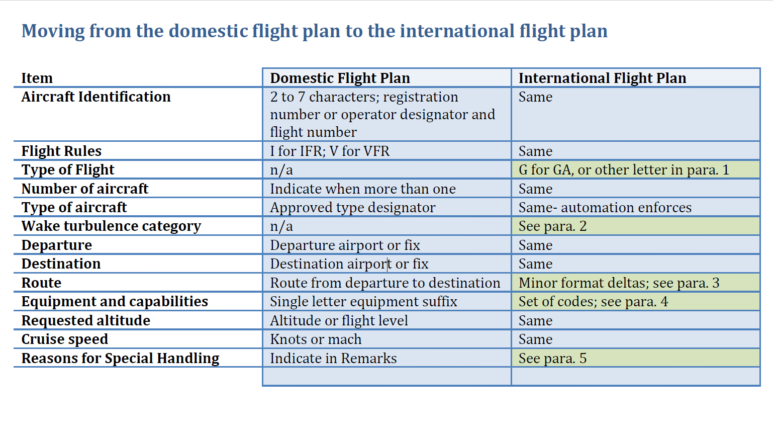
The FAA has again pushed the implementation of the international flight plan form (ICAO) for all civil domestic flights. The FAA previously delayed the mandate until January 2017, and will now plan to eliminate the use of the domestic format flight plan to "early spring" of 2017.
Formal testing of the operating systems will begin in mid-January. Upon successful completion of testing, the specific implementation date will be announced at least 30 days in advance.
ICAO flight plans contain specific information relating to the proposed flight of an aircraft and controllers use them to provide air traffic services based on the capabilities of each aircraft. Today pilots file flight plans in the U.S. under either the domestic or ICAO format, and the use of one format will simplify the process and align U.S. flight plans with ICAO standards.
This flight planning QuickTip will show you how to easily update your iFlightPlanner aircraft profiles and enjoy a seamless transition to the new ICAO flight plan format when creating and filing flight plans with iFlightPlanner. iFlightPlanner is, and has been ready since this change was first proposed in 2012!
As referenced in the video, there is a lot of aircraft-specific information required to file the ICAO flight plans. However, if you are only flying domestically the FAA requires less ICAO data.
The FAA has issued an informal guidance document that highlights changes specific to the international flight plan form that pertain exclusively to flight within the National Airspace System.
Should you have any questions specific to filing ICAO flight plans in iFlightPlanner, please don't hesitate to contact us!
The iFlightPlanner Crew
PLAN. FLY. LOG.
Monday, October 31, 2016
Monday, October 31, 2016 @ 8:00 AM
 The FAA has published the 12th Edition of the Aeronautical Chart User's Guide.
The Chart User's Guide is an introduction to the Federal Aviation Administration's (FAA) aeronautical charts and publications. It is useful to new pilots as a learning aid, and to experienced pilots as a quick reference guide.
» Download the FREE Guide
Monday, July 25, 2016
Monday, July 25, 2016 @ 8:00 AM
The FAR-FC and FAR-AMT books are available and shipping now from ASA. The FAR/AIM (which includes new 14 CFR Parts 48 and 107 pertaining to both manned aircraft and remote pilot operations) will begin shipping on August 10.

The ASA FAR/AIM Series books are indexed and show clearly-marked changes since the last release for quick reference.
Friday, April 15, 2016
Friday, April 15, 2016 @ 8:00 AM
Search by aircraft make and model in this FAA database of ADS-B equipment designed to meet the requirements of 14 CFR 91.225 and 91.227, either as separate components or complete installation solutions. The database includes both FAA-certified equipment and equipment not yet approved. See Definitions Legend at the bottom of the page for additional details.

» ADS-B Compliant Equipment Search Tool
Wednesday, March 16, 2016
Wednesday, March 16, 2016 @ 8:00 AM
While all of the information provided in the publication will remain the same, the FAA’s familiar green Airport/Facility Directory is changing its official name with the March 31 editions to the "Chart Supplement" per a Charting Notice dated March 31, 2016.
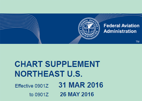
The newly named supplements for the lower 48 states, Puerto Rico, and the U.S. Virgin Islands will continue to contain complete airport data highlighting navigation, communication, weather sources, runways, obstacles, and other information necessary for safe flight. The FAA said the change will bring the Airport/Facility Directory in line with Interagency Air Cartographic (AICC) 8 specifications for printed products. Additionally, all knowledge tests, literature, and other references will soon reflect the new name, which has already been implemented for the country’s northwest region.
The change will not effect the Airport/Facility Directory available online at iFlightPlanner.com/Airports or in iFlightPlanner for iPad.
Monday, December 21, 2015
Monday, December 21, 2015 @ 8:00 AM
The iFlightPlanner Crew is excited to announce that we will be fully supporting the Bad Elf ADS-B receivers at product launch!
In 2010, Bad Elf brought aviation-grade GPS to the iPad. The Bad Elf GPS receivers became the best selling Apple approved external GPS accessory providing high performance GPS data to location-based iOS applications. Now Bad Elf is announcing their affordable ADS-B weather and traffic receiver with support from Kickstarter.

After five years of portable ADS-B receivers being on the market, less than 10% of pilots are flying with real-time, subscription-free weather and traffic in the cockpit. They cite high price and restricted compatibility as the two main reasons that they have not yet purchased an ADS-B receiver.
With Bad Elf taking a fresh approach and building their ADS-B receiver around open standards, iFlightPlanner is fully on board. We’ve never been a fan of exclusivity and we absolutely love the path that Bad Elf and others are forging with ADS-B device interoperability. Together we recognize that pilots want a choice, and a chance to find the solution that best suits their needs.

The next version of iFlightPlanner for iPad is in the final stages of testing, and we've pushed its release back to include this new opportunity with Bad Elf. Including the to-be-released Bad Elf ADS-B device, iFlightPlanner for iPad will support ADS-B connectivity for nine different manufacturers and at least thirteen different receivers, including both portable devices and certified ADS-B installations.
Be sure to keep an eye on the iFlightPlanner Blog for the latest updates on iFlightPlanner, as well as Kickstarter to learn more about the Bad Elf campaign!
Monday, November 9, 2015
Monday, November 9, 2015 @ 8:00 AM
 The FAA has announced a new plan to ensure that pilots have all the information they need as the agency phases out world aeronautical charts (WACs), with new Alaska and Caribbean charts being created to fill the gaps.
In an October 29 announcement, the FAA said it will produce an Alaska VFR Wall Planning Chart to help pilots as they plan long-distance flights. The wall chart will show all of Alaska as well as the Canadian territory between Washington State and Alaska. The FAA also will produce two new Caribbean VFR Aeronautical Charts that will provide more coverage than is available with the three WACs they will replace. The scale for the Caribbean charts will be 1 to 1 million.
The new charts should be available in early January 2017, when the existing WACs for those areas expire.
» Read more on AOPA.org
Monday, November 2, 2015
Monday, November 2, 2015 @ 8:00 AM
 Looking for a great leather bag for day trips or a deluxe headset case to match? Check out the great selection of PilotMall-branded leather bags being highlighted as our Products of the Month for the month of November!
No need to sacrifice style and splendor during short trips. Instead, pack luxury along with your belongings in any number of leather flight bags, headset cases, duffels and totes. These one-of-a-kind bags bring road warriors and frequent flyers a premium collection of top-notch components. Each is adorned with the official PilotMall.com logo, with a custom front logo available for purchases of 10 or more bags (90-day lead time required). A superb choice for effortless, on-the-go opulence you'll never again want to travel without!
Click HERE to see the full assortment of bags, get FREE SHIPPING and SAVE $5 on your first purchase of more than $100 using coupon code PLAN10!
Monday, October 5, 2015
Monday, October 5, 2015 @ 8:00 AM
Icom America recently introduced their new A220 VHF air band radio for the avionics market, featuring enhanced squelch control, a bright white display, and easy installation.
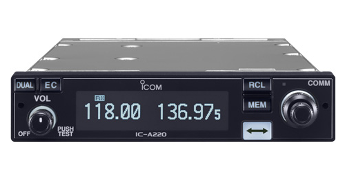
The IC-A220 builds upon the manufacturer's celebrated A210 panel mount transceiver. Like its predecessor, the Mil-Spec A220 features easy "flip-flop" channel selection to switch between main and standby channels. It also retains the A210's intercom functions and GPS memory functionality (when connected to an external receiver).
The Icom IC-A220 features a large, bright organic light emitting diode (OLED) display with white key backlighting, and an auto-dimmer function adjusts the OLED's brightness for ideal daytime or nighttime operation. It also has one-action squelch operation and automatic/manual squelch control, and offers a D-SUB 25 connector in its back panel promotes a flexible and easy installation.

Innovative features found in this next generation air band panel mount transceiver are why more pilots trust Icom as the one you add before flight. For a complete list of highlights and detailed features, visit Icom's online product page for the IC-A220 or download the complete product brochure.
Wednesday, August 26, 2015
Wednesday, August 26, 2015 @ 8:00 AM
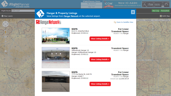
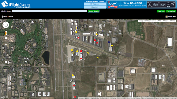
iFlightPlanner has incorporated Hangar Network’s real estate data into its flight planning tools. Now hangars and airport properties that are for sale, lease or available as transient space are viewable as an interactive layer in all of iFlightPlanner’s web-based mapping interfaces. An industry first, these new tools allow pilots to see all the space available at airports along their route of flight.
Whether buying or selling a hangar, seeking a home for a flight department or searching for transient space during an upcoming trip, iFlightPlanner and Hangar Network have brought together the best of both products to showcase all the real estate available along a flight route. Listings are updated by Hangar Network daily, allowing iFlightPlanner to provide one-click access to current, complete listing details and property information.
“Hangar Network strives to be the central resource for the aviation and airport real estate industry. Our mission is to change the way that aviators, industry professionals and the world connect to aviation real estate. By partnering with iFlightPlanner, we are revolutionizing the industry and demonstrating our ongoing commitment to finding new, better ways to navigate the aviation real estate market,” said Iver Retrum, co-founder and manager, Hangar Network. “By making this connection we are taking the first step toward creating a system where, in addition to exposing an airport’s long-term real estate options, aviators are able to communicate and make transient hangar accommodations available on a real-time basis.”
“Partnering with Hangar Network has allowed us to add even more industry-leading functionality to iFlightPlanner. Whether pilots are simply viewing our freely accessible aviation charts or planning a detailed cross-country flight and filing flight plans, finding the airport real estate to meet their needs at home or on the go has never been easier,” said Andy Matthews, co-founder & director of business development for iFlightPlanner.
Pilots may choose to overlay any combination of Hangar Network listings along their route of flight by selecting their preferred property types from the Map Layers menu found in the upper-left corner of all iFlightPlanner’s online maps. Available hangars, land, airport residential space, tie down space and warehouse/flex space are all shown.
When zoomed out, iFlightPlanner’s intelligent zoom functionality will show a summarized total of listings at each airport, and when zoomed in, or by clicking the “Zoom to Satellite View” button, users can see the precise location of each listing on the airfield with color-coded identifiers indicating their respective availability. In addition to the graphical map layer, all of Hangar Network’s listings are also available through iFlightPlanner’s comprehensive Airport/Facility Directory on the Hangars & Properties tab available for each airport.
To add an airport property listing to Hangar Network for display on iFlightPlanner, visit http://www.HangarNetwork.com/Signup to create an account!
About Hangar Network
Hangar Network is the leading resource for connecting individuals to aviation real estate. Their map-centric listing service provides unmatched access to a diverse range of airport related real estate. Hangar Network has changed the way aviators, industry professionals and the world connect to aviation real estate. In addition to a state-of-the-art listing service, Hangar Network also provides users and subscribers with the latest industry news, expert advice and industry happenings through its social media channels, newsletter and blog. For more information, please visit www.HangarNetwork.com.
Monday, August 3, 2015
Monday, August 3, 2015 @ 8:00 AM
On July 31 we launched the latest enhancements to iFlightPlanner.com. As part of this update, we introduced updated maps functionality that is part of our ongoing effort to unify the user experiences found online and in iFlightPlanner for iPad. The most noticeable feature change is the Location menu that is revealed when clicking anywhere on the map, allowing a lat/lon, airport, navaid or custom location to be added to a route with a single click. This same menu will also allow you to access iFlightPlanner's graphical airspace functionality by clicking the adjacent Airspace button.
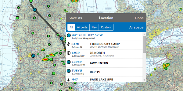
The nearby airports, navaids and custom locations can also be accessed by rubberbanding any existing waypoint or route segment to a new location. This new flight planning functionality, aside from mirroring the usability of iFlightPlanner for iPad, is aimed at making the flight planning processes simpler and more efficient.
Should you have any questions about using this, or any other feature found in iFlightPlanner, please don't hesitate to contact us!
The iFlightPlanner Crew
PLAN. FLY. LOG.
Wednesday, April 29, 2015
Wednesday, April 29, 2015 @ 8:00 AM
With the latest releases to AeroWeather Lite and AeroWeather Pro for iPhone and iPad, users will now have direct access to iFlightPlanner's Airport/Facility Directory and freely accessible VFR and IFR Low charts!
AeroWeather provides current and precise weather conditions for airports worldwide, searchable by either name or ICAO code and is a great companion to iFlightPlanner.com, mobile.iFlightPlanner.com and iFlightPlanner for iPad for pilots needing weather information outside of the United States.
Monday, April 27, 2015
Monday, April 27, 2015 @ 8:00 AM
iFlightPlanner recently announced the availability of new functionality that allows pilots to create and save flight plan files for use in the new GTN 600 and 700-series avionics by Garmin.
This innovative technology eliminates the need for pilots to manually enter complex routes. Instead, pilots can simply save a GFP file from iFlightPlanner.com to a compatible SD Card, then follow the step-by-step instructions found in the Garmin Pilot’s Guide for their particular unit to activate or store the route files.
 “iFlightPlanner is very excited to be the first flight planning resource offering file export capabilities for use in the Garmin GTN series of avionics,” said Andy Matthews, iFlightPlanner’s Co-Founder & Director of Business Development. “Safety, usability and flight planning efficiency are at the core of every new feature we develop and we believe our membership will find this technology to be an incredible asset to their flying.”
iFlightPlanner has been a leader in flight plan file creation since it first introduced this type of functionality for its members in 2012, with GFP compatibility building on iFlightPlanner’s existing FPL flight plan file creation for Garmin’s G1000 and 430/530 avionics packages. Collectively iFlightPlanner now supports five (5) different file formats – Garmin GFP and FPL, GPX, GPX for AvMap and the FMS flight plan file format used in the popular X-Plane Flight Simulator by Laminar Research.
The GFP format is compatible with the GTN 625, 635, 650, 725 and 750 models running software version 5.10 or later and requires an iFlightPlanner Premium or Premium Plus membership. It should also be noted that the GFP must be saved to a folder named “FPL” on the root of the SD Card as that is where the GTN models will look for the files.
iFlightPlanner Premium memberships with route export capabilities start at just $9.99/month and include access to iFlightPlanner’s cloud-based flight planning technology across all of its platforms, including iFlightPlanner for iPad. iFlightPlanner Free memberships are available with no obligation and allow pilots to leverage much of iFlightPlanner’s web-based technology with limited, read-only functionality on the iPad. A one-time, 30-day free trial to iFlightPlanner Premium is available via the App Store.
The iFlightPlanner Crew will be in Lakeland, FL at SUN ‘n FUN from April 21–26 in Booths D-011 and D-012. Pilots are encouraged to stop by for their personal demonstration or visit https://www.iFlightPlanner.com for more information.
Wednesday, April 8, 2015
Wednesday, April 8, 2015 @ 8:00 AM
The iFlightPlanner Crew recently got their hands on the IC-A6 VHF Air Band Transceiver from Icom and thought it would be fun and informative to share our unboxing and setup experience with the new unit.
Icom touts the A6 as the simplest, most easy to use handheld on the market. Its big brother, the IC-A24 shares the same frame but features NAV features in addition to COM for U.S. frequency ranges. Both the A6 and A24 have well-labeled, large keypads that allow for user friendly operation in flight. The large displays are capable of showing both letters and numbers making for fast frequency recognition, and both the display and keypad are backlit and will stay on until you turn it off – a very handy feature for flying at night!
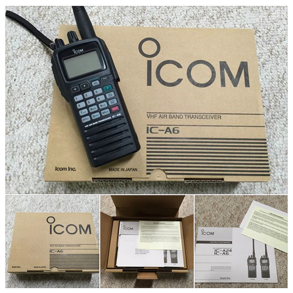
The contents of the box itself are extremely well organized and hardly require the instruction manual to get started. The unit weighs 15.2oz once the battery and antenna are installed, and the weight and water-resistant construction of the A6 instills confidence that it will withstand a few bumps and bruises without any problems. The company website has the full specifications. Supplied accessories include the antenna, belt clip, handstrap, battery pack, wall charger and headset adapter. You'll need a small Phillips head screwdriver to attach the belt clip to the battery pack that is not included.
Holding the PWR button for a couple seconds will turn the unit on and you're good to go! The left-most nob is reserved for volume, and the other (marked DIAL) is used for tuning the desired frequency, WX channel number, BANK number and memory channel. It also controls the squelch and beep tone level. All of the features are clearly detailed in the instruction manual with diagrams, graphics and helpful key sequences so that you can get the most out of the A6.
Additional Features Include:
- 200 memory channels (20 Ch × 10 banks) with 6 character names
- Dedicated 121.5MHz emergency key
- Side tone function allows you to hear your own voice via an external aviation headset
- Optional Ni-Cd and Li-Ion battery packs
- NOAA marine weather channels
- Tag scanning and memory bank scanning
- ANL (Auto Noise Limiter) for noise reduction
- Low battery alert
Icom does not do direct sales through their website, but they will help you find their nearest authorized avionics dealer where you can purchase one. Most retailers have the A6 listed around $240 but the company is offering a $30 rebate through the end of May 2015. At that price you'll be hard-pressed to find a more versatile handheld transceiver with the versatility and reliability than the Icom A6!
Wednesday, April 1, 2015
Wednesday, April 1, 2015 @ 8:00 AM
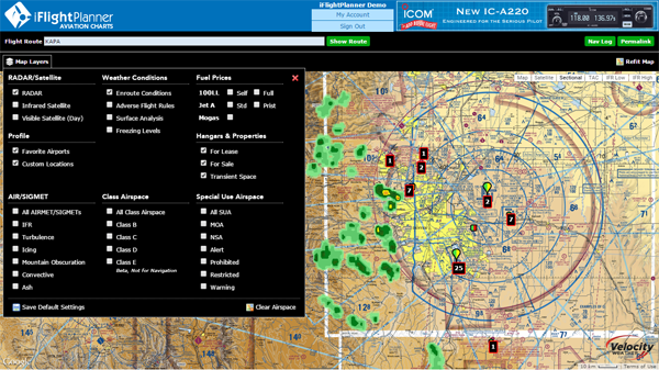
In need of a great resource to get a quick look at a route and the weather and charts along the way? Check out the freely accessible Aviation Charts resource available at iFlightPlanner.com/AviationCharts! No joke. There you'll find the complete set of U.S. Sectional, TAC and IFR Low/High Enroute Charts in the familiar Google Maps interface, updated every 28-days with data direct from the FAA!
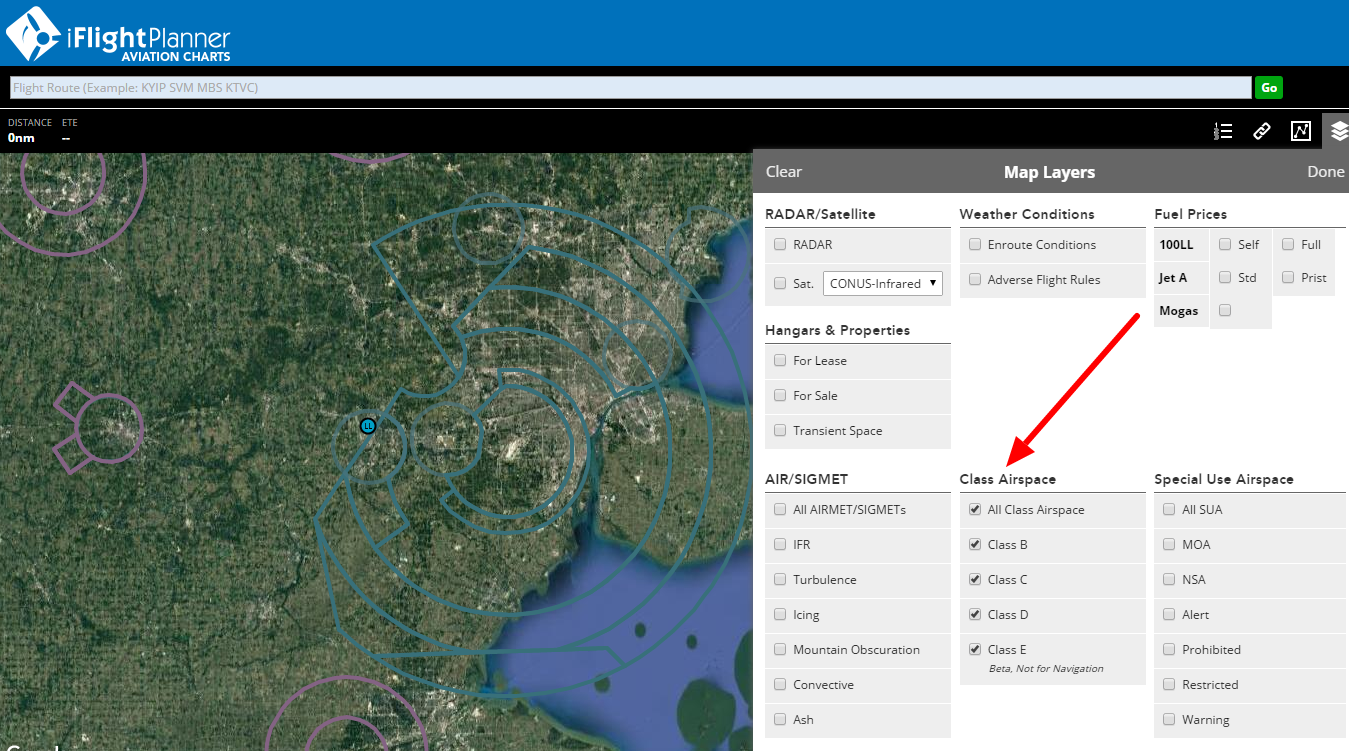
It includes the same Map Layers menu used in our Flight Planning Wizard (upper-left corner) to allow you to overlay hi-resolution RADAR and satellite imagery, as well as fuel prices, enroute conditions, graphical AIRMETs, SIGMETs, and features interactive layers for all Special Use Airspace (SUA). You can even share routes with your fellow pilots via email or your favorite social media outlet using the 'Permalink' button!
Wednesday, January 14, 2015
Wednesday, January 14, 2015 @ 8:00 AM
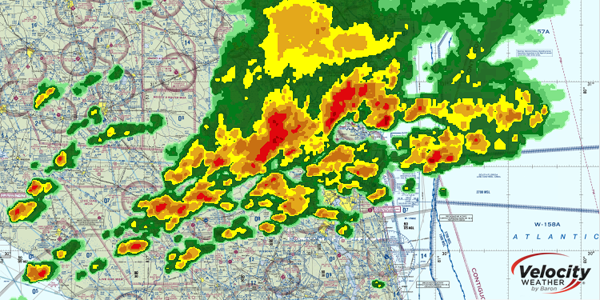
The iFlightPlanner Crew recently expanded our implementation of Velocity WEATHER by Baron to include the freely accessible aviation charts available online at iFlightPlanner.com/AviationCharts and those found as part of the iFlightPlanner Airport Weather Center and Flight Wizard for registered members.
Available map layers now include hi-resolution RADAR, Infrared and Visible Satellite imagery, all of which can be synchronized for a comprehensive visual representation of current meteorological conditions and match the presentation found in iFlightPlanner for iPad. Use the Map Layers menu in the upper-left corner of the Google Maps interface to access these great new mapping features!
Should you have any questions about this, or any of the features available to you as a Free, Premium or Premium Plus member, please don't hesitate to contact us!
Monday, December 15, 2014
Monday, December 15, 2014 @ 8:00 AM

Dovetail Games gave flight sim fans a lift for the holiday season with the announcement that Microsoft Flight Simulator X: Steam Edition will launch on December 18 at a spectacular introductory price.
Microsoft Flight Simulator X: Steam Edition delivers an authentically accurate aerial experience for simulation enthusiasts and those with a passion for all things flight. Pilots can climb into the cockpits of over twenty aircraft, from commercial and fighter jets to single-engine private planes and helicopters. More than 80 missions will test players in a variety of ways, including search and rescue challenges, test pilot scenarios, races and more. The game features updated multiplayer functionality, Windows 8.1 support and over 24,000 airports, delivering a beautiful, connected world and vast horizon begging to be explored.
» iFlightPlanner Integration with Microsoft Flight Simulator, X-Plane
Monday, November 17, 2014
Monday, November 17, 2014 @ 8:00 AM
With iFlightPlanner for iPad you now have the ability to connect your iPad to your favorite flight simulator and unleash the best flight planning and in-flight simulation experience anywhere!

Combining iFlightPlanner, FSXFlight and Lockheed Martin Prepar3D, Microsoft Flight Simulator 2004, Microsoft Flight Simulator X or the Steam Edition, pilots of all realms can plan flights using iFlightPlanner and view those routes in iFlightPlanner for iPad for use in their flight simulator. Once in the virtual cockpit, FSXFlight will push all simulated GPS data to iFlightPlanner for iPad via networked WiFi connection and force the iPad to behave as if it were flying in the same airplane!
If you fly with X-Plane, the FSXFlight plugin(s) are not required and you may connect iFlightPlanner for iPad directly to X-Plane over the same wireless network.
» iFlightPlanner Installation & Setup Guide for FSXFlight
» Connecting X-Plane to iFlightPlanner, The Details
This feature is already available to all iFlightPlanner Premium members and you can upgrade today for as little as $9.99 per month and experience all that iFlightPlanner has to offer!
Monday, October 27, 2014
Monday, October 27, 2014 @ 8:00 AM
The USGS, along with numerous state and federal partners, has launched the 3D Elevation Program (3DEP), an effort to chart all 50 states with airborne lasers (lidar) or radar (ifsar). The new technology permits astonishingly precise measurements of terrain, buildings and roads, waterways, coastline, even vegetation, right down to individual plants.

Alaska, it turns out, has never been mapped to modern standards. While the U.S. Geological Survey (USGS) is constantly refining its work in the lower 48 states, the terrain data in Alaska is more than 50 years old, much of it hand-sketched from black-and-white stereo photos shot from World War II reconnaissance craft and U-2 spy planes. Errors abound. Locals tell of mountains as much as a mile out of place. Streams flow uphill, and ridges are missing because a cloud happened by when the photo was taken.
Mars is better mapped than the state of Alaska,” said Steve Colligan, president of E-Terra, an Anchorage mapping firm that specializes in aviation safety.
» More from The Washington Post
Monday, August 11, 2014
Monday, August 11, 2014 @ 8:00 AM
The August 2014 digital issue of Avionics News Magazine is now available!
 In this month's issue, you'll find:
- The View from Washington
- International News & Regulatory Updates
- Advancing Cordless Cockpits
- AEA member profile: Vaughn College
- AEA member profile: Mid-South Calibration
- Digital data: A Security Nightmare for Businesses
- Choosing a school
- Industry professionalism
- Marketplace classifieds and much more!
For more information on the Aircraft Electronics Association visit http://www.aea.net/.
The iFlightPlanner Crew
PLAN. FLY. LOG.
Thursday, August 7, 2014
Thursday, August 7, 2014 @ 8:00 AM
Georeferenced Airport Diagrams & Approach Procedures
iFlightPlanner for iPad v2.2, featuring the comprehensive set of georeferenced FAA airport diagrams and instrument approach procedures, is now available for download from the App Store!
As part of this release, the iFlightPlanner Crew developed its own, proprietary georeferencing process so that when viewed as standalone documents, iFlightPlanner for iPad could provide the georeferenced airport diagrams and approach procedures in their original PDF format - fully leveraging the pinch and zoom capabilities of the iPad with crystal clear readability at any zoom level.
The georeferenced functionality is accessible throughout iFlightPlanner for iPad presented by Sennheiser, including its split-screen view, and can be easily placed over iFlightPlanner’s seamless VFR and IFR charts with a single tap of the "Map It" button. Pilots can then use the intuitive mini-menu to quickly search for and switch between other diagrams or approach procedures and adjust the transparency of each.
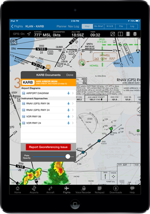
Anytime you see the aircraft icon in either the Airport/Facility directory or mini-menu (as shown above), that document is available to you as a georeferenced product when GPS is enabled on your device.
All georeferenced airport diagrams and approach procedures are available to iFlightPlanner Premium Plus members, a new membership level introduced to give pilots flying with iFlightPlanner for iPad greater functionality. Premium Plus annual memberships may be purchased for only $119.99 through August (reg. $139.99). Current iFlightPlanner Premium members who wish to upgrade to iFlightPlanner Premium Plus and prorate their existing membership may contact us for details!
Additional features in iFlightPlanner for iPad v2.2 include...
Airports
- Airports without an official FAA airport diagram will now show the A/FD page in the upper left thumbnail area.
Approach Plate Timer
- When viewing approach plates, we improved the usability of the timer by enlarging the tap area to open the timer and preventing the timer from moving up or down when the toolbar is hidden. iFlightPlanner for iPad will also now remember whether you last had the timer open or closed.
RADAR & Satellite Overlays
- You may now change the opacity of the RADAR and Satellite overlays. Simply tap the View/Split Screen Settings button above the map and move the slider. You may also save your default setting for future use!
TAC & IFR Low Charts
- We added an additional native zoom level to both the TAC and IFR Low charts tiles to enhance the readability when zooming in.
Downloads
- Unselected download types now will show as 50% transparent so that you can easily see which downloads will be performed when you tap "Download Updates."
Monday, August 4, 2014
Monday, August 4, 2014 @ 8:00 AM
Each year, the AEA publishes the Pilot's Guide to Avionics, a publication of the Aircraft Electronics Association, features articles aimed at helping pilots make better avionics buying decisions and to locate the repair stations certified by international regulatory authorities as capable of installing and maintaining these sophisticated pieces of equipment.
 Featured articles include:
- New Products for 2014
- AEA's Value-Added Equation for Aircraft Owners
- In-Flight Entertainment
- Lithium Batteries 101
- ADS-B Early Adopters
- Repair Station Directory
The 2014-15 edition of the AEA’s Pilot’s Guide to Avionics debuted during AirVenture 2014 and was available for free at AEA's AirVenture Booth, 2035/36 in Hangar B. It also can be found at NBAA and at any AEA Regional Meeting this fall.
The iFlightPlanner Crew
PLAN. FLY. LOG.
Friday, July 25, 2014
Friday, July 25, 2014 @ 8:00 AM
Our flights are planned and we're ready to depart for AirVenture 2014 with an exciting new version of iFlightPlanner for iPad presented by Sennheiser in tow!
iFlightPlanner Proficiency Seminar
 Join iFlightPlanner Co-Founders Andy Matthews and John Burnside on Wednesday, July 30 at 4:00PM in Forum 8 as they host an interactive proficiency seminar demonstrating the core features and latest enhancements to iFlightPlanner.com and iFlightPlanner for iPad that will allow you to plan more efficiently and fly safer! «SEMINAR DETAILS»
Meet the AEROSTARS
 iFlightPlanner is proud to support the AEROSTARS formation aerobatic team, who will be dazzling audiences at AirVenture at speeds over 250mph just a few feet from one another through breathtaking barrel rolls, graceful formation loops and dramatic opposing maneuvers. Like us on Facebook and follow us on Twitter to find out when you can meet the team next week!
iFlightPlanner at AirVenture
 The festivities begin on Monday, 7/28 and run through Sunday, 8/3 at the Wittman Regional Airport (KOSH)! The iFlightPlanner Crew has moved from the Sennheiser Aviation tent to Booths 2028 & 2029 just inside Hangar B with an all-new setup to showcase the latest in flight planning technology from iFlightPlanner. «HANGAR B, 2028 & 2029»
AirVenture NOTAM, Arrival/Departure Signs
 The 2014 AirVenture NOTAM specifies codes used to inform ground personnel of your desired parking area at KOSH. You'll need to display one of these signs for your arrival and another for departure based on your aircraft type and parking or camping preference. The iFlightPlanner Crew has prepared the entire set of signs ready for you to print! «NOTAM SIGNS»
We appreciate your continued support of iFlightPlanner, travel safe and we will see you in Oshkosh!
The iFlightPlanner Crew
PLAN. FLY. LOG.
Wednesday, July 23, 2014
Wednesday, July 23, 2014 @ 8:00 AM
iFlightPlanner is built on a foundation of pilot feedback, and there is no better place for pilots to have an open forum with the iFlightPlanner Crew than at AirVenture! Join Co-Founders Andy Matthews and John Burnside on Wednesday, July 30 at 4:00PM as they host an interactive proficiency seminar demonstrating the core features and latest enhancements to iFlightPlanner.com and iFlightPlanner for iPad that will allow you to plan more efficiently and fly safer!
WHAT: iFlightPlanner Proficiency Seminar
WHEN: Wednesday, July 30 at 4:00PM
WHERE: EAA Forum 8
Visit iFlightPlanner in Hangar B, Booths 2028 & 2029 or the EAA Airventure Forum Schedule for more info!
Friday, July 11, 2014
Friday, July 11, 2014 @ 8:00 AM
The award-winning creators of the best-selling Train Simulator franchise have today announced a global licensing deal with Microsoft, granting them the rights to develop and publish all-new flight products based on Microsoft’s genre-defining flight technology.
First released in 2006, Microsoft Flight Simulator X is widely acknowledged as one of the most popular simulation products on the market. Microsoft Flight Simulator X: Steam Edition will include the Deluxe Edition and the Acceleration Expansion Pack in one bundle. Dovetail Games will bring Microsoft Flight Simulator X: Steam Edition to the Steam online gaming platform for the first time in late 2014.
Flight Simulator X + iFlightPlanner for iPad
With the release of iFlightPlanner for iPad v2.0, you have the ability to connect your iPad to Flight Simulator X via a plugin called FSX Flight. Once in the virtual cockpit, FSXFlight will push all simulated GPS data to iFlightPlanner for iPad via networked WiFi connection and force the iPad to behave as if it were flying in the same airplane.
This feature is already available to all iFlightPlanner Premium members and you can upgrade today for as little as $9.99 per month and experience all that iFlightPlanner has to offer!
Wednesday, July 9, 2014
Wednesday, July 9, 2014 @ 8:00 AM
 Aircraft Spruce customers who need merchandise and will be attending AirVenture can save the shipping costs by picking up orders at the show.
Since only a limited amount of stock can be brought to Oshkosh, Aircraft Spruce is encouraging you to place your orders for the AirVenture Show by phone, fax, or online ahead of time. Orders will be processed as normal with payment via credit card, but instead of shipping the order to you, they will place it on their truck and bring it to the Aircraft Spruce Oshkosh booths (Hangar A, Booths 1022 to 1029) for you to pick up, with no shipping charges!
» Place Your Order
Friday, June 27, 2014
Friday, June 27, 2014 @ 8:00 AM
AirVenture 2014 is fast approaching and we have all hands on deck here in Ann Arbor preparing for what is going to be a great week in Oshkosh, July 28-August 3! In the meantime we have a few new features and enhancements that we would like to share with you...
GPX File Import/Export Capabilities
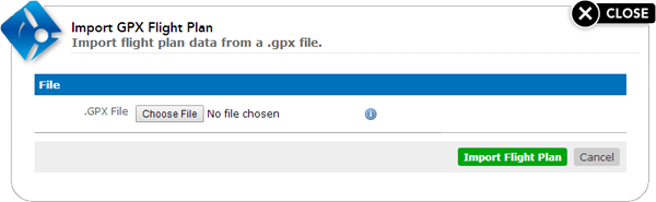
 iFlightPlanner Premium Members now have the ability to import .GPX flight plan files into iFlightPlanner to assist in the planning of flight routes. This new functionality compliments the already popular feature of being able to save routes planned on iFlightPlanner to the .GPX and Garmin .FPL flight plan file formats for use in compatible avionics packages. «IMPORT/EXPORT»
Enhanced TFR Processing
 iFlightPlanner recently upgraded its behind-the-scenes processing of Temporary Flight Restrictions from http://tfr.faa.gov for all map views available on iFlightPlanner.com and iFlightPlanner for iPad. While every effort is made to ensure the accuracy of TFRs, please double check current NOTAMS before you fly! «GRAPHICAL TFR»
ZULU Time by The Jardur Watch Co.
 The Jardur Watch Company has been named the exclusive timekeeper of iFlightPlanner and will be the presenting sponsor of the official ZULU (GMT) time found throughout our web-based flight planning products. Look for "ZULU by Jardur" in the lower-right corner of your web browser! «JARDUR WATCH CO.»
AirVenture 2014
The iFlightPlanner Crew will be in Hangar B this year, Booths 2028 & 2029, just to your right as you walk in the main hangar door. Our expanded presence will allow us to show you all the latest features that are soon to be released to make your iFlightPlanner experience the best yet!
Monday, June 23, 2014
Monday, June 23, 2014 @ 8:00 AM
iFlightPlanner Premium Members now have the ability to import .GPX flight plan files into iFlightPlanner to assist in the planning of flight routes. This new functionality compliments the already popular feature of being able to save routes planned on iFlightPlanner to the .GPX and Garmin .FPL flight plan file formats for use in compatible avionics packages.
The Import GPX Flight Plan feature is found under your Favorite Routes List. If you're not yet an iFlightPlanner Premium member you can upgrade today for as little as $9.99 per month!
Monday, June 2, 2014
Monday, June 2, 2014 @ 8:00 AM
The June 2014 digital issue of Avionics News Magazine is now available!
 In this month's issue, you'll find:
- The View from Washington: Culture
- International News & Regulatory Updates
- Standby Glass: Bringing Consistency to Digital Panels
- AEA Member Profile: Airtech
- AEA Member Profile: A Plus Avionics
- Ongoing Evolution: How the Cockpit Upgrade Business Changed
- ADS-B installations Beginning to Take Off
- Business Basics: How to Deal with Workplace Abuse
For more information on the Aircraft Electronics Association visit http://www.aea.net/.
The iFlightPlanner Crew
PLAN. FLY. LOG.
Monday, May 19, 2014
Monday, May 19, 2014 @ 8:00 AM
iFlightPlanner officially announced today that the Jardur Watch Company has been named the exclusive timekeeper of iFlightPlanner and will be the presenting sponsor of the official ZULU (GMT) time found across iFlightPlanner’s web-based flight planning products.
 The Jardur Import Company, established in 1937 in New York City, quickly earned its reputation among U.S. military and professional pilots as one of the most trusted manufacturers of aviation watches and navigation plotters available. Management of precise time is critical to the success of every mission for this special class of users for whom the brand catered to. In fact, Jardur was so highly regarded among them that Lieutenant Colonel James "Jimmy" Doolittle was presented with a Jardur Bezelmeter 960 by James Howard “Dutch” Kendelberger (former President of North American Aviation) in recognition of his leadership and planning of the April 18, 1942 “Doolittle Raid” on Tokyo, Japan.
The original Jardur Import Company closed its doors in 1960 and left an incredible history in aviation dormant until it was resurrected in 2011 by now Jardur Watch Company President, CC Shermer. “This partnership with iFlightPlanner is very important to Jardur because it allows us to pay respect to the legacy of Samuel Klepper and the original Jardur Import Company while celebrating the innovative aviation technology that is developed by iFlightPlanner and used by so many pilots today.”
Pilots who use iFlightPlanner and its web-based Flight Wizard to plan routes, retrieve certified weather briefs, calculate weight & balance and file their flight plans will now see the Jardur logo complimenting the ZULU (GMT) time in the lower-right corner of their web browser throughout their flight planning. Andy Matthews, iFlightPlanner’s Co-Founder & Director of Business Development further described the integration by saying, “Not only will Jardur’s presence make it easy for pilots to identify the current universal time, it will serve as a reminder of times past and the craftsmanship that in so many ways set the foundation for how we now electronically plan flights.”
The first aviation chronograph launched under the revitalized Jardur Watch Company, the Degreemeter, pays homage to the original World War II era Bezelmeter 960 while incorporating all of the advancements in materials, manufacturing methods and design features which comprise state-of-the-art watchmaking. The Degreemeter along with the ZULU, the next model to be released in Jardur’s Escadrille series, will be available for purchase in the iFlightPlanner Shop and from the Jardur website, http://www.Jardur.com.
James Wingfield, Jardur’s Vice President of Engineering, summarizes the new relationship between the two companies perfectly. “Every flight, from takeoff to landing, is under the control of a temporal odometer,” he said. “Fuel consumption, airspeed and even the most complex navigation calculations depend on accurate timing by pilots and the timing technology they employ. We could not be more excited to build on the legacy of Jardur with iFlightPlanner through this innovative partnership, and we all look forward to the next time history is made with a Jardur timepiece!”
For more information about the Jardur Watch Company and its Escadrille series of aviation chronographs, please visit http://www.Jardur.com.
Monday, May 12, 2014
Monday, May 12, 2014 @ 8:00 AM
The May 2014 digital issue of Avionics News Magazine is now available!
 In this month's issue, you'll find:
- The View from Washington: Tale of Two Conventions
- International News & Regulatory Updates
- AEA Board of Directors: David Loso, Jet Aviation St. Louis
- AEA Member Profile: UTC Aerospace Systems
- AEA Member Profile: Western Airways
- Five Years In: EFBs Lighten Flight Bags, Pile on Options
- Legal Ease: The shifting FAA paradigm of 'Design Organization'
- Aviation Aces: Tim Brouwer, Mayday Avionics
For more information on the Aircraft Electronics Association visit http://www.aea.net/.
The iFlightPlanner Crew
PLAN. FLY. LOG.
Friday, May 2, 2014
Friday, May 2, 2014 @ 8:00 AM
iFlightPlanner for iPad v2.1, the second major update this month to iFlightPlanner for iPad presented by Sennheiser, is now available on the App Store! Featured in this release are several all-new features that were the direct result of feedback the iFlightPlanner Crew received from attendees at SUN 'n FUN just a few weeks ago; namely recently issued ATC routes, range rings, extended runway centerlines and pages from the FAA's printed Airport/Facility Directories.
 Recently Issued ATC Routes, "Cleared as filed..."
Routes issued by ATC within the past thirty (30) days are now available as a routing type in iFlightPlanner for iPad. Simply select "Recent ATC Route" as your routing method to view a list of routes that you are likely to receive clearance for. In addition to the routing, you'll see the number of times that route has been issued, the date and time of last issuance and its altitude range!
 Range Rings & Extended Runway Centerlines
Range rings and extended runway centerlines are now available as map overlays in iFlightPlanner for iPad. Just tap the overlays button at the top right of the map view to toggle them on/off. Range Rings will automatically size based on your current zoom level and runway extensions will be visible for any airports that are part of your current route at appropriate zoom levels.
 Sectional Chart Improvements
In conjunction with the FAA's recently updated Sectional chart format the iFlightPlanner Crew completely redeveloped its proprietary chart processing software, resulting in higher resolution and more accurate georeferencing. The enhanced chart imagery for Sectionals and TACs will be released with the May 1, 2014 data cycle!
 FAA "Green Book" A/FD Pages
The official Airport/Facility Directory pages from the FAA's infamous "Green Books" are now available as part of the Airport Diagrams download in iFlightPlanner for iPad. For all airports that are listed in the FAA's printed A/FD, the PDF of that page will be the first document available on the Documents & Frequencies section of the Airports tab.
 Aircraft Location Icon
By popular request, we've added a transparent white circle around the aircraft location icon and a pulsing blue ring to increase the visibility of your location on the map view in iFlightPlanner for iPad.
Thursday, May 1, 2014
Thursday, May 1, 2014 @ 4:01 AM
Official FAA data for the 05/01/14 cycle was updated today at 09:01Z, including airport diagrams, approach plates and all-new charts!
In conjunction with the FAA's recently updated Sectional chart format the iFlightPlanner Crew completely redeveloped its proprietary chart processing software, resulting in higher resolution and more accurate georeferencing for all of its charting products.
Anytime you access iFlightPlanner.com or mobile.iFlightPlanner.com you can be confident that you are seeing the most current and accurate data available. To ensure that iFlightPlanner for iPad is current, simply tap "Check for Updates" in the upper-left corner of the Downloads tab. The app will quickly tell you which files need to be updated!
The iFlightPlanner Crew
PLAN. FLY. LOG.
Wednesday, April 16, 2014
Wednesday, April 16, 2014 @ 8:00 AM
By Mary Grady, AVweb
 ADS-B is now installed nationwide, the FAA announced Monday, although services won't be available at all air traffic facilities until 2019. "The installation of this radio network clears the way for air traffic controllers to begin using ADS-B to separate equipped aircraft nationwide," said FAA Administrator Michael Huerta in a statement. "It will also provide pilots flying aircraft equipped with the proper avionics with traffic information, weather data and other flight information."
Of the 230 air traffic facilities across the country, 100 are currently using ADS-B to separate traffic, according to the FAA. All aircraft operating in controlled airspace must be equipped with ADS-B Out avionics that broadcast the plane's location by Jan. 1, 2020.
» More on AVweb
Monday, April 14, 2014
Monday, April 14, 2014 @ 8:00 AM
Dave Allen from Other People's Airplanes talks with iFlightPlanner's Co-Founder Andy Matthews about the latest updates to iFlightPlanner for iPad and iFlightPlanner.com, including iOS 7 updates and all-new Cockpit Voice and Flight Data Recorders.
Other People’s Airplanes is an internet-based video show (or podcast) where Dave Allen brings you into the cockpit of, well, other people’s airplanes! He mounts high definition cameras anywhere he can in and on airplanes whenever @DaveFlys. He then produces a fresh episode of the show for you to watch with your own eyeballs!
In addition to documenting other people's airplanes, Dave videos some of the best and most exciting news from Sebring, SUN 'n FUN and AirVenture. He's been a great supporter of iFlightPlannner and we were excited to share with him the release of iFlightPlanner for iPad v2.0!
» Other People's Airplanes
Wednesday, April 9, 2014
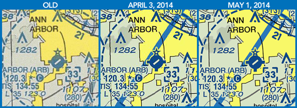
Wednesday, April 9, 2014 @ 8:00 AM
Beginning with the April 3, 2014 data cycle, the Federal Aviation Administration (FAA) began distributing new, high-resolution digital charts. Electronic flight planning resources, including iFlightPlanner.com, iFlightPlanner for iPad and all iFlightPlanner competitors who use the AeroNav Office's digital charting products benefit from the new production process.
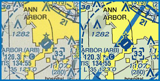
Previously, digital charts were distributed as scans of the actual paper charts that are sold by your local pilot shop. The AeroNav Office is now, in the simplest of terms, distributing the original graphics files that would be used to print the paper chart. The new process removes a time consuming step that also caused a significant loss in image quality, and the results are quite dramatic!
Since iFlightPlanner first introduced georeferenced charts, the iFlightPlanner Crew has used an internal, proprietary process that allows us to deliver all seamless U.S. VFR, IFR and TAC charts to our members at no cost. Pilots can be confident that anytime they are viewing charts on iFlightPlanner.com/AviationCharts, in the Flight Wizard or via iFlightPlanner for iPad they are seeing the most current and accurate data available. (To ensure that iFlightPlanner for iPad is current, simply tap the 'Check for Updates' button in the upper-left corner of the Downloads tab. The app will quickly tell you which files need to be updated!)
We know you'll enjoy the new visuals. Should you have any questions about the new charts please do not hesitate to contact us, we'll be happy to share any insight!
The iFlightPlanner Crew
PLAN. FLY. LOG.
